-
AircraftTakeoff WeightFolded Dimensions (Without propellers)Unfolded Dimensions (Without propellers)Max Ascent Speed (No Wind)Max Descent Speed (No Wind)Max Horizontal Speed (At Sea Level, No Wind)Max Takeoff AltitudeMax Flight Time (per Battery)Max Flight DistanceMax Flight AltitudeMaximum Wind Resistance LevelMax Tilt AngleOperating TemperatureGlobal Navigation Satellite SystemHovering Accuracy RangeTargeting MethodFlight ConditionMaximum SD Card MemoryVideo TransmissionMax Transmission Distance (Free Of Interference)Live View QualityOperating FrequencyCameraLensImage Resolution Stored on PhoneImage Resolution Stored on SD CardPhoto FormatVideo Resolution Stored on PhoneVideo Resolution Stored on SD CardVideo FormatLens Adjustable AngleSupported File SystemDigital ZoomGimbal StructureDrone BatteryCapacityWeightNominal VoltageMax Charging VoltageTypeEnergyCharging Temperature (Optimum)Charging TimeRemote ControllerCapacityMax Operating TimeCharging TimePhone Holder Max WidthFeatureFunction ListApplication Scenario
-
 F11PRO 2 Plus(RC4)
USD $379.88
278g5.90×3.94×2.36 in (L×W×H)9.06×7.68×2.36 in (L×W×H)5.58ft/s5.58ft/s22.96ft/s6562ft26 minutes1640ft394ftLevel 530°0°C to 40°CGPS+GLONASSVertical: ±1.64ft Horizontal: ±1.64ftGPS+GLONASS Barometer Optical flow sensorIndoors/Outdoors32GB1640ft720p@25fps2.4G+5.8GSony3840x21603840x2160JPEG1280x720@25fps2560×1440@25fps 3840×2160@15fpsMP4-90° to 0°FAT32————1900mAh83.5g7.6V5VLi-ion14.44Wh5°C to 40°C2.5 hours3.7V 500mAh3.5 hours1 hour3.35in1. Aerial Photography 2. One Key Lifting 3. Smart Return 4. GPS Follow 5. Filters 6. VR 7. Way Point 8. Orbit 9. App Joystick1. Aerial Photography 2. Family Interactive Entertainment 3. Safe Cruise 4. Farm Inspection
F11PRO 2 Plus(RC4)
USD $379.88
278g5.90×3.94×2.36 in (L×W×H)9.06×7.68×2.36 in (L×W×H)5.58ft/s5.58ft/s22.96ft/s6562ft26 minutes1640ft394ftLevel 530°0°C to 40°CGPS+GLONASSVertical: ±1.64ft Horizontal: ±1.64ftGPS+GLONASS Barometer Optical flow sensorIndoors/Outdoors32GB1640ft720p@25fps2.4G+5.8GSony3840x21603840x2160JPEG1280x720@25fps2560×1440@25fps 3840×2160@15fpsMP4-90° to 0°FAT32————1900mAh83.5g7.6V5VLi-ion14.44Wh5°C to 40°C2.5 hours3.7V 500mAh3.5 hours1 hour3.35in1. Aerial Photography 2. One Key Lifting 3. Smart Return 4. GPS Follow 5. Filters 6. VR 7. Way Point 8. Orbit 9. App Joystick1. Aerial Photography 2. Family Interactive Entertainment 3. Safe Cruise 4. Farm Inspection -
 F11MINI
USD $379.99
245g5.91×3.35×2.16 in (L×W×H)11.81×8.46×2.16 in (L×W×H)9.84ft/s6.56ft/s26.25ft/s6562ft30 minutes1640ft394ftLevel 430°0°C to 40°CGPS+GLONASSVertical: ±1.64ft Horizontal: ±1.64ftGPS+GLONASS Barometer Optical flow sensorIndoors/Outdoors128GB1640ft720p@25fps 2K@25fps5.8GSony4096×30724096×3072JPEG1280x720@25fps 2048x1080@25fps2048x1080@50fps 2688x1512@25fpsMP4-90° to 0°FAT32————2100mAh83g7.6V5VLi-ion15.96Wh5°C to 40°C3.5 hours3.7V 380mAh10 hours1 hour3.27in1. Aerial Photography 2. One Key Takeoff/landing 3. Smart Return 4. GPS Follow 5. Waypoints 6. Points of Interest 7. App Joystick 8. Recording 9. VR1. Aerial Photography 2. Family Interactive Entertainment 3. Safe Cruise 4. Farm Inspection
F11MINI
USD $379.99
245g5.91×3.35×2.16 in (L×W×H)11.81×8.46×2.16 in (L×W×H)9.84ft/s6.56ft/s26.25ft/s6562ft30 minutes1640ft394ftLevel 430°0°C to 40°CGPS+GLONASSVertical: ±1.64ft Horizontal: ±1.64ftGPS+GLONASS Barometer Optical flow sensorIndoors/Outdoors128GB1640ft720p@25fps 2K@25fps5.8GSony4096×30724096×3072JPEG1280x720@25fps 2048x1080@25fps2048x1080@50fps 2688x1512@25fpsMP4-90° to 0°FAT32————2100mAh83g7.6V5VLi-ion15.96Wh5°C to 40°C3.5 hours3.7V 380mAh10 hours1 hour3.27in1. Aerial Photography 2. One Key Takeoff/landing 3. Smart Return 4. GPS Follow 5. Waypoints 6. Points of Interest 7. App Joystick 8. Recording 9. VR1. Aerial Photography 2. Family Interactive Entertainment 3. Safe Cruise 4. Farm Inspection -
 U11MINI
USD $259.99
235g5.55×3.42×2.44 in (L×W×H)12.71×10.67×2.44 in (L×W×H)13ft/s6ft/s39ft/s9842ft35 minutes9842ft394ftLevel430°50°to 104°F (10°to 40°C)GPS+GLONASSVertical: ±1.64ft Horizontal: ±1.64ftGPS+GLONASS Barometer Optical flow sensor TOFIndoors/Outdoors64GB9842ftFAT325.8GSony3840x2160P3840x2160JPEG1280x720P @20fps2976×1680P @30FPS 3840×2160P @20FPSMP4-90° to 0°FAT32————2200mAh95 g /3.35 oz7.6V5VLi-ion15.96Wh5°C to 40°CAbout 3 Hours(Depending on Charging Power)3.7V 3000mAh3.3 hours4 hour6.7 in1. Aerial Photography 2. One Key Takeoff/landing 3. Smart Return 4. GPS Follow Me 5. Image Follow 6. Waypoints 7. Point of Interest 8. Zoom 9. Ges Photo And Ges Record 10. Recording 11. Filter and Music 12. VR1. Aerial Photography 2. Family Interactive Entertainment 3. Safe Cruise 4. Farm Inspection
U11MINI
USD $259.99
235g5.55×3.42×2.44 in (L×W×H)12.71×10.67×2.44 in (L×W×H)13ft/s6ft/s39ft/s9842ft35 minutes9842ft394ftLevel430°50°to 104°F (10°to 40°C)GPS+GLONASSVertical: ±1.64ft Horizontal: ±1.64ftGPS+GLONASS Barometer Optical flow sensor TOFIndoors/Outdoors64GB9842ftFAT325.8GSony3840x2160P3840x2160JPEG1280x720P @20fps2976×1680P @30FPS 3840×2160P @20FPSMP4-90° to 0°FAT32————2200mAh95 g /3.35 oz7.6V5VLi-ion15.96Wh5°C to 40°CAbout 3 Hours(Depending on Charging Power)3.7V 3000mAh3.3 hours4 hour6.7 in1. Aerial Photography 2. One Key Takeoff/landing 3. Smart Return 4. GPS Follow Me 5. Image Follow 6. Waypoints 7. Point of Interest 8. Zoom 9. Ges Photo And Ges Record 10. Recording 11. Filter and Music 12. VR1. Aerial Photography 2. Family Interactive Entertainment 3. Safe Cruise 4. Farm Inspection -
 U11MINI 4K
USD $449.99
less than 250g5.55×3.42×2.28 in (L×W×H)12.59×7.56×2.28 in (L×W×H)14ft/s6ft/s45ft/s9842ft32 minutes20,000 feet (Measured under no-wind conditions after disabling Low Battery Return to Home with flight restrictions lifted, flying horizontally at a constant speed of 9 m/s at sea level until forced landing is triggered).394ftLevel 530°0°C - 40°C(32°F-104°F)GPS+GLONASSVertical: ±1.64ft Horizontal: ±0.98ftGPS+GLONASS Barometer Optical flow sensor TOFIndoors/Outdoors256GB20000ft720@30fps5.8GSony3840x2160P8000x6000PJPG1280x720P3840x2160P@30fps 1920x1080P@60fpsMP4-90° to 0°FAT325×3-axis brushless gimbal2200mAh/7.6V93g/3.28 oz7.6V5VLipo 2S16.72Wh5°C to 40°C(41°F to 104°F )PD 3.0(Depending on Charging Power)3.7V 3000mAh100 minutes4 hour3.15 in1. Aerial Photography 2. One Key Takeoff/landing 3. Smart Return 4. GPS Follow 5. Point of Interest 6. Image Follow 7. Route Rules 8. Zoom 9. Switch Vertical Screen 10. Recording 11. Filter 12. VR 13 Lens Angle 14.Ges Quickshot 15.Ges Record 16.Music 17.Return Update 18.Watermark 19.Image Parameter Adjustment 20. alarm1. Aerial Photography 2. Family Interactive Entertainment 3. Safe Cruise 4. Farm Inspection$659.99$659.99£509.99£369.99U11MINI 4K
U11MINI 4K
USD $449.99
less than 250g5.55×3.42×2.28 in (L×W×H)12.59×7.56×2.28 in (L×W×H)14ft/s6ft/s45ft/s9842ft32 minutes20,000 feet (Measured under no-wind conditions after disabling Low Battery Return to Home with flight restrictions lifted, flying horizontally at a constant speed of 9 m/s at sea level until forced landing is triggered).394ftLevel 530°0°C - 40°C(32°F-104°F)GPS+GLONASSVertical: ±1.64ft Horizontal: ±0.98ftGPS+GLONASS Barometer Optical flow sensor TOFIndoors/Outdoors256GB20000ft720@30fps5.8GSony3840x2160P8000x6000PJPG1280x720P3840x2160P@30fps 1920x1080P@60fpsMP4-90° to 0°FAT325×3-axis brushless gimbal2200mAh/7.6V93g/3.28 oz7.6V5VLipo 2S16.72Wh5°C to 40°C(41°F to 104°F )PD 3.0(Depending on Charging Power)3.7V 3000mAh100 minutes4 hour3.15 in1. Aerial Photography 2. One Key Takeoff/landing 3. Smart Return 4. GPS Follow 5. Point of Interest 6. Image Follow 7. Route Rules 8. Zoom 9. Switch Vertical Screen 10. Recording 11. Filter 12. VR 13 Lens Angle 14.Ges Quickshot 15.Ges Record 16.Music 17.Return Update 18.Watermark 19.Image Parameter Adjustment 20. alarm1. Aerial Photography 2. Family Interactive Entertainment 3. Safe Cruise 4. Farm Inspection$659.99$659.99£509.99£369.99U11MINI 4K -
 U11MINI 4K RC3
USD $659.99
less than 250g5.55×3.42×2.28 in (L×W×H)12.59×7.56×2.28 in (L×W×H)14ft/s6ft/s45ft/s9842ft32 minutes20,000 feet (Measured under no-wind conditions after disabling Low Battery Return to Home with flight restrictions lifted, flying horizontally at a constant speed of 9 m/s at sea level until forced landing is triggered).394ftLevel 530°0°C - 40°C(32°F-104°F)GPS+GLONASSVertical: ±1.64ft Horizontal: ±0.98ftGPS+GLONASS Barometer Optical flow sensor TOFIndoors/Outdoors256GB20000ft720@30fps5.8GSony3840x2160P8000x6000PJPG1280x720P3840x2160P@30fps 1920x1080P@60fpsMP4-90° to 0°FAT325×3-axis brushless gimbal2200mAh/7.6V93g/3.28 oz7.6V5VLipo 2S16.72Wh5°C to 40°C(41°F to 104°F )PD 3.0(Depending on Charging Power)3.7V 3000mAh100 minutes4 hour3.15 in1. Aerial Photography 2. One Key Takeoff/landing 3. Smart Return 4. GPS Follow 5. Point of Interest 6. Image Follow 7. Route Rules 8. Zoom 9. Switch Vertical Screen 10. Recording 11. Filter 12. VR 13 Lens Angle 14.Ges Quickshot 15.Ges Record 16.Music 17.Return Update 18.Watermark 19.Image Parameter Adjustment 20. alarm1. Aerial Photography 2. Family Interactive Entertainment 3. Safe Cruise 4. Farm Inspection$659.99£485.59U11MINI-4K-RC3
U11MINI 4K RC3
USD $659.99
less than 250g5.55×3.42×2.28 in (L×W×H)12.59×7.56×2.28 in (L×W×H)14ft/s6ft/s45ft/s9842ft32 minutes20,000 feet (Measured under no-wind conditions after disabling Low Battery Return to Home with flight restrictions lifted, flying horizontally at a constant speed of 9 m/s at sea level until forced landing is triggered).394ftLevel 530°0°C - 40°C(32°F-104°F)GPS+GLONASSVertical: ±1.64ft Horizontal: ±0.98ftGPS+GLONASS Barometer Optical flow sensor TOFIndoors/Outdoors256GB20000ft720@30fps5.8GSony3840x2160P8000x6000PJPG1280x720P3840x2160P@30fps 1920x1080P@60fpsMP4-90° to 0°FAT325×3-axis brushless gimbal2200mAh/7.6V93g/3.28 oz7.6V5VLipo 2S16.72Wh5°C to 40°C(41°F to 104°F )PD 3.0(Depending on Charging Power)3.7V 3000mAh100 minutes4 hour3.15 in1. Aerial Photography 2. One Key Takeoff/landing 3. Smart Return 4. GPS Follow 5. Point of Interest 6. Image Follow 7. Route Rules 8. Zoom 9. Switch Vertical Screen 10. Recording 11. Filter 12. VR 13 Lens Angle 14.Ges Quickshot 15.Ges Record 16.Music 17.Return Update 18.Watermark 19.Image Parameter Adjustment 20. alarm1. Aerial Photography 2. Family Interactive Entertainment 3. Safe Cruise 4. Farm Inspection$659.99£485.59U11MINI-4K-RC3
-
AircraftTakeoff WeightFolded Dimensions (Without propellers)Unfolded Dimensions (Without propellers)Max Ascent Speed (No Wind)Max Descent Speed (No Wind)Max Horizontal Speed (At Sea Level, No Wind)Max Takeoff AltitudeMax Flight Time (per Battery)Max Flight DistanceMax Flight AltitudeMaximum Wind Resistance LevelMax Tilt AngleOperating TemperatureGlobal Navigation Satellite SystemHovering Accuracy RangeTargeting MethodFlight ConditionMaximum SD Card MemoryVideo TransmissionMax Transmission Distance (Free Of Interference)Live View QualityOperating FrequencyCameraLensImage Resolution Stored on PhoneImage Resolution Stored on SD CardPhoto FormatVideo Resolution Stored on PhoneVideo Resolution Stored on SD CardVideo FormatLens Adjustable AngleSupported File SystemDigital ZoomDrone BatteryCapacityWeightNominal VoltageMax Charging VoltageTypeEnergyCharging Temperature (Optimum)Charging TimeRemote ControllerCapacityMax Operating TimeCharging TimePhone Holder Max WidthFeatureFunction ListApplication Scenario
-
 F11PRO
USD $379.99
520g6.93×4.13×3.15 in (L×W×H)17.52×15.94×3.15 in (L×W×H)6.56ft/s4.92ft/s27.88ft/s9842ft30 minutes3937ft394ftLevel 630°0°C to 40°CGPS+GLONASSVertical: ±1.64ft Horizontal: ±1.64ftGPS+GLONASS BarometerOutdoors128GB1640ft720p@30fps5.8GSony3840x21602976x1680JPEG1280x720@30fps2976x1680@30fpsMP4-90° to 0°FAT325×2500mAh193g11.1V5VLi-ion27.75Wh5°C to 40°C4.5 hours3.7V 300mAh10 hours40 minutes3.19in1. Aerial Photography 2. One Key Lifting 3. Smart Return 4. GPS Follow 5. Filter And Music 6. VR 7. Route Rules 8. Fly Around 9. Zoom 10. Recording 11. Ges Photo And Ges Record1. Aerial Photography 2. Family Interactive Entertainment 3. Safe Cruise 4. Farm Inspection
F11PRO
USD $379.99
520g6.93×4.13×3.15 in (L×W×H)17.52×15.94×3.15 in (L×W×H)6.56ft/s4.92ft/s27.88ft/s9842ft30 minutes3937ft394ftLevel 630°0°C to 40°CGPS+GLONASSVertical: ±1.64ft Horizontal: ±1.64ftGPS+GLONASS BarometerOutdoors128GB1640ft720p@30fps5.8GSony3840x21602976x1680JPEG1280x720@30fps2976x1680@30fpsMP4-90° to 0°FAT325×2500mAh193g11.1V5VLi-ion27.75Wh5°C to 40°C4.5 hours3.7V 300mAh10 hours40 minutes3.19in1. Aerial Photography 2. One Key Lifting 3. Smart Return 4. GPS Follow 5. Filter And Music 6. VR 7. Route Rules 8. Fly Around 9. Zoom 10. Recording 11. Ges Photo And Ges Record1. Aerial Photography 2. Family Interactive Entertainment 3. Safe Cruise 4. Farm Inspection
-
AircraftTakeoff WeightFolded Dimensions (Without propellers)Unfolded Dimensions (Without propellers)Max Ascent Speed (No Wind)Max Descent Speed (No Wind)Max Horizontal Speed (At Sea Level, No Wind)Max Takeoff AltitudeMax Flight Time (per Battery)Max Flight DistanceMax Flight AltitudeMaximum Wind Resistance LevelMax Tilt AngleOperating TemperatureGlobal Navigation Satellite SystemHovering Accuracy RangeTargeting MethodFlight ConditionMaximum SD Card MemoryVideo TransmissionMax Transmission Distance (Free Of Interference)Live View QualityOperating FrequencyCameraLensImage Resolution Stored on PhoneImage Resolution Stored on SD CardPhoto FormatVideo Resolution Stored on PhoneVideo Resolution Stored on SD CardVideo FormatLens Adjustable AngleSupported File SystemDigital ZoomGimbal StructureDrone BatteryCapacityWeightNominal VoltageMax Charging VoltageTypeEnergyCharging Temperature (Optimum)Charging TimeRemote ControllerCapacityMax Operating TimeCharging TimePhone Holder Max WidthFeatureFunction ListApplication Scenario
-
 F11GIM2
USD $579.99
560g7.48×4.13×3.15 in (L×W×H)17.72×15.94×3.15 in (L×W×H)14.76ft/s4.92ft/s (Height range: 98ft to 394ft) 3.28ft/s (Height range: 16ft to 98ft) 0.98ft/s (Height range: Within 16ft)32.81ft/s9842ft28 minutes9800ft394ftLevel 630°0°C to 40°CGPS+GLONASSVertical: ±1.64ft Horizontal: ±1.64ftGPS+GLONASS BarometerOutdoors128GB9800ft720p@30fps2.4G+5.8GSony3840x21603840x2160JPEG1280x720@30fps3840x2160@30fpsMP4-80° to 0°FAT325×2-Axis Gimbal + EIS2500mAh193g11.1V5VLi-ion27.75Wh5°C to 40°C4.5 hours3.7V 1500mAh2 hours2 hours3.62in1. Aerial Photography 2. One Key Takeoff/landing 3. Smart Return 4. GPS Follow Me 5. Image Follow 6. Waypoints 7. Point of Interest 8. Zoom 9. Ges Photo And Ges Record 10. Recording 11. Filter and Music 12. VR1. Aerial Photography 2. Family Interactive Entertainment 3. Safe Cruise 4. Farm Inspection
F11GIM2
USD $579.99
560g7.48×4.13×3.15 in (L×W×H)17.72×15.94×3.15 in (L×W×H)14.76ft/s4.92ft/s (Height range: 98ft to 394ft) 3.28ft/s (Height range: 16ft to 98ft) 0.98ft/s (Height range: Within 16ft)32.81ft/s9842ft28 minutes9800ft394ftLevel 630°0°C to 40°CGPS+GLONASSVertical: ±1.64ft Horizontal: ±1.64ftGPS+GLONASS BarometerOutdoors128GB9800ft720p@30fps2.4G+5.8GSony3840x21603840x2160JPEG1280x720@30fps3840x2160@30fpsMP4-80° to 0°FAT325×2-Axis Gimbal + EIS2500mAh193g11.1V5VLi-ion27.75Wh5°C to 40°C4.5 hours3.7V 1500mAh2 hours2 hours3.62in1. Aerial Photography 2. One Key Takeoff/landing 3. Smart Return 4. GPS Follow Me 5. Image Follow 6. Waypoints 7. Point of Interest 8. Zoom 9. Ges Photo And Ges Record 10. Recording 11. Filter and Music 12. VR1. Aerial Photography 2. Family Interactive Entertainment 3. Safe Cruise 4. Farm Inspection -
 F11PRO 2
USD $459.99
357g6.5×3.54×2.56 in (L×W×H)13.78×15.16×2.56 in (L×W×H)8ft/s9ft/s26ft/s10000ft35 minutes10000ft394ftLevel530°0°C to 40°CGPS+GLONASSVertical: ±1.64ft Horizontal: ±1.64ftGPS+GLONASS Barometer Optical flow sensorIndoors/Outdoors128GB10000ft1280x720@25fps5.8GSony5700x3200P5700x3200P 4096x3072P 3840x2160PJPEG1280x720P @25fps3840×2160P @30FPSMP4-90° to 0°FAT325×3-Axis brushless Gimbal3200mAh126.5 g /4.46 oz7.7V5VLi-ion24.64Wh5°C to 40°CAbout 2.5 Hours(Depending on Charging Power)3.7V 3600mAh4 hours3.5 hour3.5 in1. Aerial Photography 2. One Key Takeoff/landing 3. Smart Return 4. GPS Follow Me 5. Flight Around 6. Night Mode 7. Route planning 8. Zoom 9. Vertical Screen 10. Recording 11. Filter 12. VR 13. Lens Angle1. Aerial Photography 2. Family Interactive Entertainment 3. Safe Cruise 4. Farm Inspection
F11PRO 2
USD $459.99
357g6.5×3.54×2.56 in (L×W×H)13.78×15.16×2.56 in (L×W×H)8ft/s9ft/s26ft/s10000ft35 minutes10000ft394ftLevel530°0°C to 40°CGPS+GLONASSVertical: ±1.64ft Horizontal: ±1.64ftGPS+GLONASS Barometer Optical flow sensorIndoors/Outdoors128GB10000ft1280x720@25fps5.8GSony5700x3200P5700x3200P 4096x3072P 3840x2160PJPEG1280x720P @25fps3840×2160P @30FPSMP4-90° to 0°FAT325×3-Axis brushless Gimbal3200mAh126.5 g /4.46 oz7.7V5VLi-ion24.64Wh5°C to 40°CAbout 2.5 Hours(Depending on Charging Power)3.7V 3600mAh4 hours3.5 hour3.5 in1. Aerial Photography 2. One Key Takeoff/landing 3. Smart Return 4. GPS Follow Me 5. Flight Around 6. Night Mode 7. Route planning 8. Zoom 9. Vertical Screen 10. Recording 11. Filter 12. VR 13. Lens Angle1. Aerial Photography 2. Family Interactive Entertainment 3. Safe Cruise 4. Farm Inspection -
F11GIM
USD $489.99
560g7.48×4.13×3.15 in (L×W×H)17.72×15.94×3.15 in (L×W×H)6.56ft/s4.92ft/s27.88ft/s9842ft28 minutes4921ft394ftLevel 630°0°C to 40°CGPS+GLONASSVertical: ±1.64ft Horizontal: ±1.64ftGPS+GLONASS BarometerOutdoors128GB3900ft720p@30fps5.8GSony3840x21603840x2160JPEG1280x720@30fps3840x2160@30fpsMP4-80° to 0°FAT325×2-Axis Gimbal + EIS2500mAh193g11.1V5VLi-ion27.75Wh5°C to 40°C4.5 hours3.7V 300mAh10 hours40 minutes3.62in1. Aerial Photography 2. One Key Takeoff/landing 3. Smart Return 4. GPS Follow Me 5. Image Follow 6. Waypoints 7. Point of Interest 8. Zoom 9. Ges Photo And Ges Record 10. Recording 11. Filter and Music 12. VR1. Aerial Photography 2. Family Interactive Entertainment 3. Safe Cruise 4. Farm Inspection
-
ModuleModelWorking ModeCharging TimeWorking TimeBattery CapacityOperating VoltageProduct SizeProduct WeightPackage Content
-
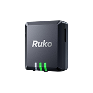 R111
USD $39.99
R111Bluetooth4 / Bluetooth5About 40 minutesAbout 4 hours150mAh3.7V38*34*13.5 mm / 1.50*1.34*0.53 inAbout 13g / 0.46oz1×Remote ID Module 2×Velcro 2×Double-sided tape 8×Self-locking zip tie 1×Adjustable zip tie mount 1×Type-C Charging Cable 1×User Manual
R111
USD $39.99
R111Bluetooth4 / Bluetooth5About 40 minutesAbout 4 hours150mAh3.7V38*34*13.5 mm / 1.50*1.34*0.53 inAbout 13g / 0.46oz1×Remote ID Module 2×Velcro 2×Double-sided tape 8×Self-locking zip tie 1×Adjustable zip tie mount 1×Type-C Charging Cable 1×User Manual